
The land surveying industry in Ohio is a critical component of the state’s real estate and development landscape. Companies like Exacta Land Surveyors LLC and Millman National Land Services are leading the charge, utilizing advanced technology to provide precise property boundary determinations, site planning, and field surveys. This article delves into the industry’s role, technological progress, and the services offered by these key players, as well as the legal requirements and considerations for selecting a reputable land surveyor in Ohio.
Key Takeaways
- Land surveying is essential for Ohio’s development, with firms offering services ranging from boundary surveys to site planning and construction layout.
- Technological advancements, such as GPS and advanced mapping tools, have significantly improved the accuracy and efficiency of land surveys in Ohio.
- When choosing a land surveyor in Ohio, it’s important to consider their accreditation, ratings, and adherence to legal requirements, including state-specific regulations and parcel split guidelines.
Exploring the Landscape of Ohio’s Land Surveying Industry
The Role of Land Surveyors in Real Estate and Development
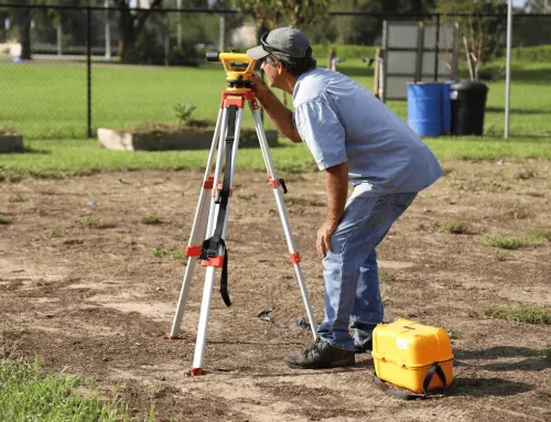
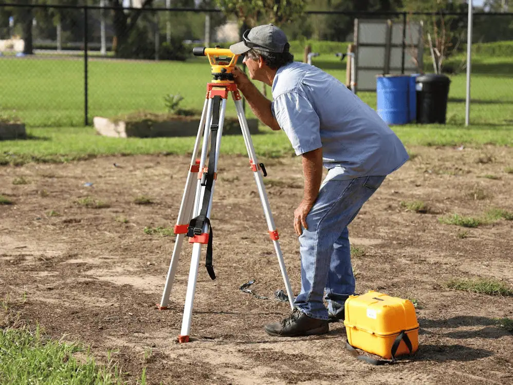
When you’re venturing into the realm of real estate and development in Ohio, understanding the commercial land usage, zoning regulations, and the benefits of drone surveys is crucial. Ohio surveyors are at the forefront of this process, providing essential services that shape the success of your projects. A professional land surveyor is really important for figuring out where things are, spotting any problems, and checking plans.
Here’s what you can expect from Ohio’s land surveying services:
- Boundary Surveys to delineate property lines for legal clarity
- Zoning Services to navigate the complex local regulations
- Drone Surveys for a comprehensive aerial perspective of the site
Companies like Exacta Land Surveyors LLC and Millman National Land Services leverage cutting-edge technology to deliver precise and efficient surveying solutions. With their expertise, you can minimize legal disputes and ensure that your development plans are grounded in accurate and reliable data.
Technological Advancements in Surveying
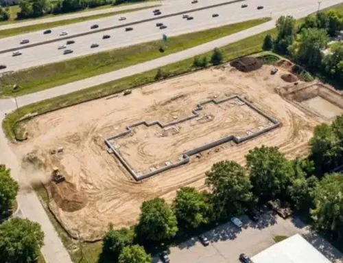
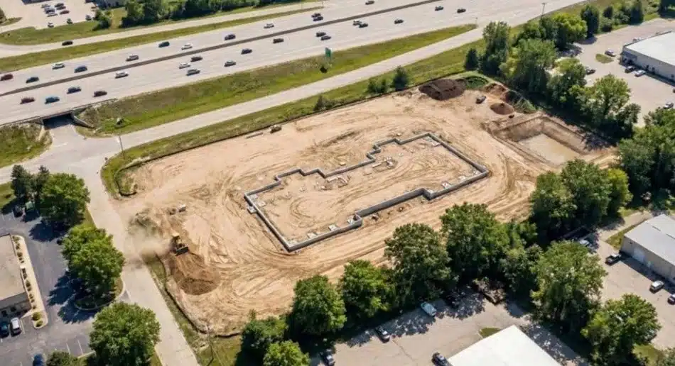
As you navigate the commercial land usage and zoning landscape in Ohio, understanding the impact of technological advancements in surveying is crucial. Drone surveys, or sUAS, have revolutionized the industry, offering a bird’s-eye view that is invaluable for planning and zoning services. These aerial surveys provide comprehensive data, including topography, boundaries, and potential obstructions, which are essential for informed decision-making.
Boundary, location, and ALTA/ACSM surveys detail boundaries, locations, and land titles, critical for any commercial development project. With the advent of technology, topographic surveyors now employ sophisticated tools such as theodolites, laser scanners, and GPS to tackle complex projects with precision. For your topographic survey needs, it’s imperative to consult professionals who are equipped with the latest technology.
When considering a surveyor for your project, take into account the following:
- The availability of existing survey monumentation in the area
- Seasonal factors like foliage and crops that may affect surveying
- Terrain features, such as whether the land is hilly or flat
These factors can influence the time and resources needed for a survey, and a knowledgeable surveyor will account for them to ensure accuracy and efficiency.
Related: ALTA Survey – Land Surveying Services
Key Players: Spotlight Millman National Land Services
When you’re delving into the realm of commercial real estate in Ohio, understanding the landscape is crucial. Millman National Land Services stand out as beacons of excellence in this field. With their finger on the pulse of the latest zoning regulations and commercial land usage, these companies ensure that your projects are grounded in precision and legal compliance.
Millman National Land Services, headquartered in Canton, Ohio, brings to the table a wealth of experience in handling multi-state and high-volume transactions. They operate with a steadfast adherence to ALTA standards and local guidelines, ensuring that every survey is conducted with the utmost precision and scalability.
- Embrace the future of land surveying with drone surveys that offer an aerial perspective and unmatched detail.
- Ensure your commercial project aligns with zoning laws by consulting with industry leaders.
- Opt for companies that prioritize technological advancements for efficient and precise surveying outcomes.
Navigating Land Surveying Services in Ohio

Comprehensive Surveying Services Offered by Ohio Companies
When you’re delving into the commercial real estate market in Ohio, understanding the lay of the land is crucial. Ohio’s land surveying firms offer a wide array of services that cater to the intricate needs of commercial land usage and zoning. These companies are equipped with the latest in drone survey technology, ensuring that you receive the most accurate and comprehensive data for your project.
Ohio’s land surveying services include, but are not limited to:
- ALTA/ACSM Land Title Surveys
- Zoning Location Surveys
- Topographic and Utility Surveys
- Construction Staking
- Site Planning and Development
Navigating the legal landscape of land surveys can be complex, but with the right surveyor, you’re in capable hands. Look for firms that not only have a strong portfolio of services but also boast accreditation and positive ratings.
Related: What Are the Different Types of Land Zoning?
Understanding the Legal Requirements for Land Surveys in Ohio
When you’re delving into commercial land development or zoning in Ohio, understanding the legal landscape is crucial. Land surveyors measure and map land boundaries using physical landmarks, and it’s essential for you to be present during the survey to ensure accuracy. Before you initiate any survey, remember that Ohio law requires surveys to be conducted by a licensed surveyor for any parcel splits to be officially recognized.
Commercial projects often come with a unique set of zoning regulations and potential flood zone considerations. Here’s a quick checklist to guide you through the legalities:
- Verify the surveyor’s license with the State of Ohio.
- Consult with the County Engineer’s Office for township-specific regulations and flood zone information.
- Ensure that your survey adheres to local village regulations if within village limits.
Professional services are available for property line surveys, and they often incorporate cutting-edge technologies like drone surveys to provide you with the most accurate data. Choosing the right surveyor is not just about compliance; it’s about securing the precision needed for your project’s success.
Related: Detailed Zoning Reports and ALTA Surveys
Choosing the Right Surveyor: Accreditation and Ratings Overview
When it comes to commercial land development, zoning intricacies, and the utilization of drone surveys, selecting the right land surveyor is paramount. Ensure your surveyor is accredited and holds a favorable rating to guarantee the precision and legality of your surveys. Look for surveyors who specialize in ALTA/NSPS Land Title Surveys, as they are held to high standards and are well-versed in the complexities of commercial properties.
Surveyors in Ohio must adhere to stringent regulations, including state-specific licensing and ongoing education to stay abreast of the latest industry advancements. Here’s a checklist to guide you:
- Verify the surveyor’s BBB rating and accreditation.
- Confirm their expertise in commercial zoning and land use.
- Ensure they offer advanced services like drone technology for accurate and efficient surveying.
By taking these steps, you can confidently navigate the landscape of Ohio’s land surveying industry and secure services that align with your commercial objectives.
When it comes to professional land surveying services in Ohio, precision and compliance are paramount. At Millman National Land Services, we offer a comprehensive suite of services including ALTA Land Surveys, Zoning Compliance Reports, and Environmental Site Assessments tailored to meet your specific needs. Our dedicated team ensures that every project, whether it’s for commercial real estate or individual property owners, is handled with the utmost care and expertise.
Don’t navigate the complexities of land surveying alone. Visit our website today to get a free quote and learn more about how we can assist you with your land surveying needs in Ohio.
Conclusion

The land surveying industry in Ohio is a critical component of the state’s real estate and development landscape. With a diverse array of services offered by companies such as Exacta Land Surveyors LLC, Castle Surveying LLC, and Viox & Viox, clients have access to precise and efficient surveying solutions for a variety of projects. These firms utilize advanced technology and possess extensive expertise, ensuring that property boundaries are accurately determined and site planning is executed with the utmost precision. Whether for residential, commercial, or infrastructural needs, Ohio’s land surveyors are equipped to support informed decision-making and contribute to the state’s growth and development.


