
A land survey is a detailed record of your property. A surveyor will take document the features, lay of the land, dimensions of the property, and the natural boundaries. All of this information is drawn into a two-dimensional map. However, to create this map, the surveyor will mark the property with stakes, flags, and steel rods for varying purposes. These items will be marked with a wide variety of symbols and acronyms. This guide will help you understand the symbols and terms of the land surveyor.
Are you in need of land services? Millman offers exactly what you need.
Common Surveyor Symbols
Due to the nature of their work, a surveyor uses numerous physical markings while surveying a property. These markings include flags, tape, and stakes, which may be color-coded or marked with acronyms. This is a short list of some of these markings provided by the Fractracker Alliance.
Surveyor flags and tape
Surveyor flags (sometimes referred to as streamers) and tape are attached to trees, fences, or a stake placed by the survey. Sometimes these flags and tape will have colors and symbols that explain what the surveyor found in that spot. Other times, these markings may lack symbolism, which could mean it could be part of a path or a proposed work site.
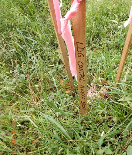
Control Points
Similar to surveyor flags, a control point is a place on the property that the surveyor does not want to be disturbed. Frequently the area will be surrounded by a perimeter line using stakes and tape. In some cases, the metal pins will be used in place of wood stakes.
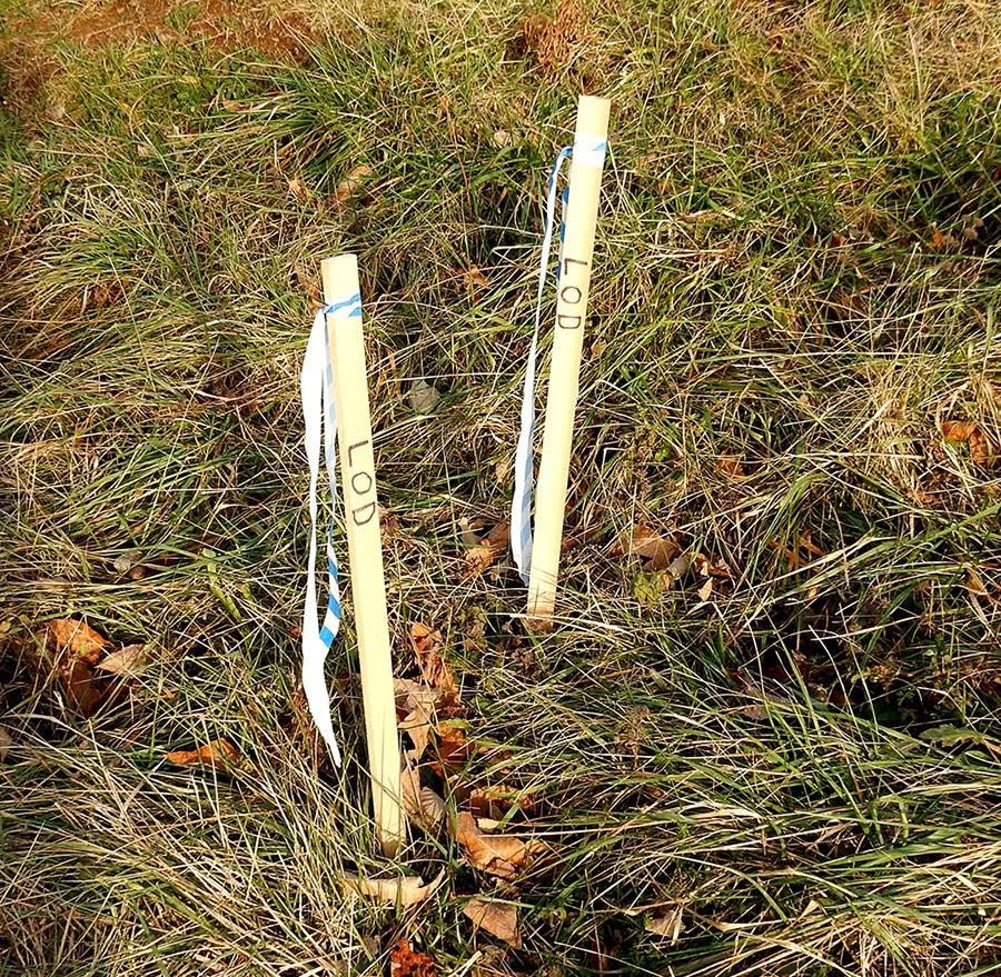
Limit of Disturbance
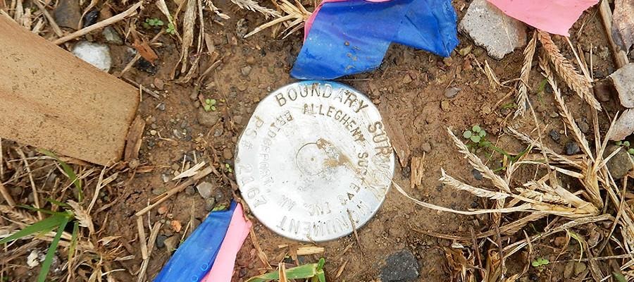
Using special stakes and markings, the surveyor will mark the limit of disturbance. This is either the edge of the property or a section of the property that cannon be disturbed. The edge of the property, especially the corners, is usually marked using a boundary survey monument or a steel rod.
Related: Planning and Zoning
Common Abbreviations
Due to the nature of the surveyor’s work, especially when marking maps, flags, and tags, acronyms and other abbreviations are often used. These abbreviations can be as short as three capital letters or segments of words. This explains some of the more common abbreviations, but please read this PDF provided by the Chicago Title Insurance Company for a more comprehensive list.
- BRL – Building Restriction Line
- BS – Back Sight
- BSL – Building Setback Line
- CIP – Capped Iron Pin
- CL – Center Line
- Con Mon F – Concrete Monument Found
- EBL – East Boundary Line or Eastbound Lane
- EIP – Existing Iron Pipe
- FD – Found
- IPF – Iron Pipe/Pin found
- IPS – Iron Pipe/Pin Found
- IRF – Iron Rod Found
- IRS – Iron Rod Set
- L.O.D. – Limit of Disturbance
- LS – Licensed/Land Surveyor
- MBS – Minimum Building Setback
- NBL – North Boundary Line or Northbound Lane
- N/F – Now or Formerly
- NIP – New Iron Pin
- NMS – No Monument Set
- NPP – Nail in Power Pole
- PI – Point of Intersection
- PK – Point Known
- PK Nail – A concrete nail stamped PK (Parker Kaelon)
- POB – Point of Beginning
- PRC – Point of Reserve Curve
- PSDE – Private Storm Drain Easement
- PT – Point of Tangency
- R/C – Rod and Cap or Rebar and Cap
- SBL – South Boundary Line or Southbound Lane
- SC – Standard Corner
- SCM – Steel Rebar
- SRS – Steel Rod Set
- STE – Sight Triangle Easement
- UE – Utility Easement
- WBL – West Boundary Line or Westbound Lane
- WC – Witness Corner
Related: Millman Blog
Surveyor Terms
As with any industry, a surveyor possesses a large vocabulary of technical terms. While some of these terms are common for anyone to understand, some are highly specific. This list explains some of the more common technical terms, but for a more comprehensive list, please read this PDF.
- Arroyo – A small and steep-walled dry watercourse with a flat floor. Also known as a gulch or gully (most commonly in the American Southwest)
- Bank – The edge of a stream.
- Bed and Banks – Refers to the bottom of a body of water found on the property.
- Bottom – The land beside a river.
- Branch – a small stream. Also known as a brook or creek.
- Drain – A stream that had since dried.
- Ford – A shallow point in a stream that can be crossed on foot.
- Fork – The meeting point of two streams.
- Gut – A stream that passes through a narrow passed between hills.
- Head – The source of a stream.
- Headwaters – Smaller streams that combine to create a larger stream.
- Kill – The Dutch word for creek
- Narrows – A narrow part of a stream.
- Run – A small stream.
- Shoal – A shallow point of a river or stream.
- Spring – A body of water fed by a natural spring.
- Thalweg – An imaginary line connecting the lowest points of a stream’s channel.
- Vly – The Dutch word for swampy lowland.
Surveyor Slang Terms
By nature, most professions use a combination of official terms and slang, and surveyors are no different. Over time, surveyors have developed an extensive vocabulary that most people would find strange and confusing, but most surveyors would understand quickly. For a comprehensive list of slang terms used by professional surveyors, please view this PDF provided by Direct Line Software.
- Balls – Numeric code .00. for example, 4-balls translates to 4.00
- Box – A data collector
- Bullseye – Zero degrees of incline
- Burn one – To measure one foot at a time with a measuring tape rather than the entire length of the tape. This is done to increase the accuracy of the measurement.
- Cap – A metal or plastic cover used for rebar or piping. The cap is typically stamped with an identifier, such as the surveyor’s license number.
- Dummy – The base or end of a measuring tape or chain.
- Legs – A tripod.
- Rodman – the person tasked with holding the rod with the EDM prism. Formerly called a chainman.
- Shoot – to take a distance measurement with an EDM.
- Zero – a perfect zero, whether it is in terms of degrees, minutes, or second.
Related: About Us
Final Thoughts
As with any industry, the vocabulary and technical tools of a land surveyor can be complicated and confusing. A combination of technical terms, slang, acronyms, abbreviations, and colored flags and tape mark the stakes and rods used by the surveyors. After reading this list, you now understand the most common terms and symbols used by surveyors.
Want to learn more about Millman’s services? Contact us today!


